Santubong National Park
If you’re thinking for a jungle-and-sea adventure near Kuching, Santubong National Park delivers in spades. Draped over a rainforest-cloaked peninsula and crowned by the unmistakable peak of Mount Santubong, it’s one of Sarawak’s most popular hiking playgrounds.
The park blends steep, ladder-laced summits with gentler waterfall rambles and a lovely loop through coastal dipterocarp forest—so you can scale up or down depending on your fitness and mood.
 Santubong National Park Entrance, walking distance to Sarawak Cutural Village.
Going into Santubong National Park
Who’s it for? Pretty much anyone who loves wild green places. The summit is a true workout that rewards the fitter, sure-footed hiker, while the shorter trails suit relaxed walkers and families. In short: Suitable for nature lovers who are fit to hike. If you’re deciding whether you’re ready for the climb, read on—we’ll help you pick the right route and prepare properly.
Orientation is simple. Start at the Santubong National Park headquarters (HQ) near the Santubong village side of the peninsula. You’ll register here, get the latest trail status, and note cut-off times. The rangers are friendly and pragmatic—ask about recent rain, ladder conditions, and recommended turn-around timings for your group. No entrance fee is required to enter this national park.
Leave your contacts with the rangers as they will call you if necessary to ensure your whereabout and that you are safe.
 Santubong National Park Headquarter is the starting point of your hike. Ask the rangers for tips on the duration and trails as well as the conditions of the forest before starting out.
 Snap a picture of the trail map to help you get the best of your hiking adventure.
When to go? Sarawak is tropical year-round, but the relatively drier window typically runs from about June to August, with shoulder months May and September also decent. The wetter monsoon months (roughly November to February) can bring slippery slopes and streams that swell quickly.
Always check with the official website of Sarawak Forestry whether the park is open for hiking as they may be closed during the monsoon months from Oct/Nov to Mar.
You will need to start early if you are going to the summit. Registration to go to the summit is from 8am-9am(weekdays) and 7am-9am(weekends-Sat,Sun and public holidays). You will not be allowed to go to the summit if you arrive later than 9am. You can arrive before 12pm if you are not going to the summit. No entry is permitted after 12pm.
Trail duration at a glance from HQ, round trip times for an average, fit hiker in good weather:
- Mount Santubong summit: 7–9 hours
- Loop trail (a scenic circuit without the summit): 4–6 hours
- Waterfall trail (shorter, gentler hiking): 1.5–3 hours
Actual times vary with pace, group size, rest stops, and conditions—always check with the rangers before you set off.
 Use the ropes to help you cross the river.
The Mount Santubong summit trail is the signature challenge. Expect a strenuous jungle climb with sections of steep roots, boulder scrambles, and a memorable sequence of ladders near the top. It’s not a technical climb, but it is physical and exposed in places, so a good head for heights helps. Fit hikers often go up in 3.5–4.5 hours and descend in 3–4 hours.
The ascent unfolds in character: a warm-up through lowland forest, then a steady push past buttress roots and vines, before the slope steepens into hands-on scrambling. You’ll cross small streams, duck beneath giant boulders, and eventually reach the ladder zone—sturdy, but slippery when wet.
At 810m, the summit is surrounded by dense vegetation. You won’t get a 360-degree panorama, but there are peekaboo viewpoints on ledges and clearings along the upper ridge that frame the South China Sea, mangroves, and the Damai coastline. Most hikers break for a late picnic just below the top, then begin the careful descent before mid-afternoon to ensure daylight all the way down.
 Bridge can be slippery when wet. Walk carefully
 Follow the water pipes and you will be on the right track.
 Tall trees make the trails not so hot even in the afternoon.
 Tall trees
 Waterfalls
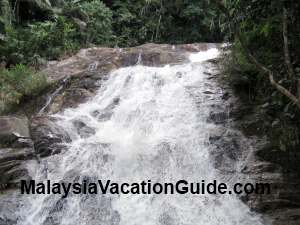
For something gentler, the waterfall trail is a crowd-pleaser. It threads along cool streams beneath tall canopies to small cascades and natural pools. Plan 1.5–3 hours return from HQ, depending on how far you roam and how long you linger. Rocks get slick—move slowly, and give the water extra respect after heavy rain.
Short on time? Ask the rangers about brief spur paths to boulders, river bends, or low viewpoints near the HQ. These little wanderings take 30–60 minutes and make easy add-ons if you’re warming up your legs for a bigger hike the next day.
The rainforest here is lush and layered. You’ll walk beneath towering dipterocarps (meranti and keruing among them), with strangler figs, rattans, and lianas weaving the mid-story. Near streams, look for gingers and ferns; on drier ridges, pandanus (screwpines) and hardy shrubs cling to rocky ground. In season, small wild orchids and colorful fungi pop from mossy trunks.
Wildlife is around, though often heard before it’s seen. Long-tailed macaques are regulars; you may also spot silvered langurs (silvery leaf monkeys) moving quietly through the higher branches. Birdlife is a treat—listen for hornbills (Oriental pied and sometimes rhinoceros), drongos, and sunbirds, and scan streams for kingfishers. Squirrels of several sizes zip about the canopy.
 Take note of the signages to help you along.
 Off to the summit
Closer to the ground, butterflies patrol sunny clearings, and dragonflies hover along watercourses. After rain, you might encounter leeches—annoying but harmless; we’ll share tips below. Evening hikers (on very short trails) sometimes hear frog choruses at the creeks, and it’s not unusual to see skinks or a shy monitor lizard sliding off the path.
Safety and etiquette are simple and important. Register at HQ, heed posted cut-off times for the summit, and log your return. Stick to marked trails and follow ribbons/signage—shortcuts erode the forest and can get you lost. In wet weather, reconsider the summit; ladders and steep roots are unforgiving when slick. Group up, look out for each other, and avoid solo summit attempts.
 Plenty of mushrooms can be seen here.
Footwear and tools: wear sturdy hiking shoes or boots with aggressive grip; the terrain is rooty and often muddy. Trekking poles help on the long descent and stream approaches (collapse them for ladder sections). Lightweight gloves improve grip on ladders and rough ropes. A compact sit-pad or small towel is handy for damp rest stops.
Water and food: the heat and humidity are real. For the summit, carry 3–4 liters per person plus electrolytes; for the loop, 1.5–2.5 liters; for the waterfall trail, 1–1.5 liters. Pack salty snacks, nuts, fruit or sandwiches. Aim to nibble every hour and sip steadily. All trash goes out with you.
Clothing and weather armor: choose quick-dry shirts and shorts or light pants; add a breathable rain jacket or poncho and a light windbreaker for breezy ridges or sudden showers. A cap, sunscreen, and sunglasses protect against exposed sections. Bring a headlamp even for day hikes—delays happen—and stash a dry change of clothes and flip-flops in your car.
Navigation and communications: while the park trails are established, signal can be patchy. Download an offline map, carry a simple compass, and note major junctions. A whistle is a smart addition. If hiking with friends, agree on regroup points (e.g., before ladder sections) and a firm turn-around time. For groups, nominate a front leader and a sweep and keep the pace inclusive.
Bites and blisters: use insect repellent and consider leech socks in the wet season. A minimalist first-aid kit—blister plasters, bandages, antiseptic wipes, an elastic wrap, and antihistamines—covers the common issues. Bee and wasp encounters are uncommon on trail, but give any buzzing clusters a wide berth and move on calmly.
 Moss
Moss Stop to learn about the trees that have been labelled.
 Typical tree that have been growing there for decades.
 Enjoy the view from F7
A sample summit day looks like this: 8:00 am, register and start; steady hiking with short breaks gets you to the ladder zone late morning; enjoy a quick lunch near the top; begin descending by 1–2 pm; aim back at HQ by 4 pm. If you’re behind schedule, respect your turn-around time—there’s no shame in saving the last stretch for a drier, brighter day.
In summary, Santubong National Park packs a lot into a compact peninsula: a tough, satisfying climb up Mount Santubong, a scenic loop for strong walkers, and refreshing waterfall meanders for easy days. Pick your path, prep smart, and you’ll have a brilliant outing close to Kuching’s coast. Enjoy..
Terengganu | Perak | Malaysia Hotels | Airlines | Shopping
Pulau Perhentian | Beaches & Islands | Highlands | Theme Parks
Museums & History | Landmarks | Public Transports | Videos
Souvenir | Calendar 2026 | Tourism Centre | Cyberjaya | Golfing
Penang Food | KTM | Beruas Museum | Selangor | Templer's Park
Pulau Ketam | KLIA2 | Pulau Sibu | Advertise With Us
Recent Articles
-
Malaysia Travel News
May 27, 26 11:48 AM
 Here is the latest Malaysia Travel News 2026 to help you while you are in various parts of the country.
 -
Berjaya Hills Resort
May 25, 26 09:52 AM
 Stay for a night at Berjaya Hill Resort for a getaway to natural surroundings. You will not miss the opportunity to take plenty of photos at the French-themed resort.
 -
Negeri Sembilan
Apr 22, 26 11:27 AM
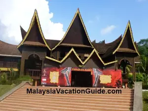 Negeri Sembilan is the only state in Malaysia that practises Adat Perpatih matrilineal system. Unique architecture include roofs in the shape of buffalo-horn.
 -
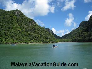
Port Dickson Attractions
Apr 22, 26 11:11 AM
 Port Dickson is a popular destination for city dwellers who just need to take a break from city life and relax in the tranquility of the Straits of Melaka Sea.
 -
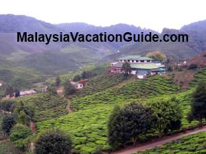
Cameron Highlands
Mar 15, 26 11:22 AM
 Cameron Highlands is one of Malaysia's hill resort destination for those who want to take time off to enjoy its cool air and beautiful scenery. You can jungle trek, visit tea plantation, farms ...


New! Comments
Have your say about what you just read! Leave us a comment in the box below.